


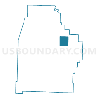
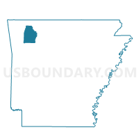
Purdy Voting District, Madison County, Arkansas
About
Outline

Summary
| Unique Area Identifier | 527230 |
| Name | Purdy Voting District |
| County | Madison County |
| State | Arkansas |
| Area (square miles) | 13.27 |
| Land Area (square miles) | 13.24 |
| Water Area (square miles) | 0.03 |
| % of Land Area | 99.76 |
| % of Water Area | 0.24 |
| Latitude of the Internal Point | 36.08829280 |
| Longtitude of the Internal Point | -93.59254010 |
Maps

Graphs
Select a template below for downloading or customizing gragh for Purdy Voting District, Madison County, Arkansas


Neighbors
Neighoring Voting District (by Name) Neighboring Voting District on the Map
- Kings River Voting District, Madison County, AR
- Marble Voting District, Madison County, AR
- War Eagle 1 Voting District, Madison County, AR
- War Eagle 2 Voting District, Madison County, AR
- Whorton Voting District, Madison County, AR
Top 10 Neighboring County Subdivision (by Population) Neighboring County Subdivision on the Map
- War Eagle township, Madison County, AR (4,037)
- Wharton township, Madison County, AR (418)
- Marble township, Madison County, AR (318)
- Purdy township, Madison County, AR (314)